Photo spot in Gosau & the Gosausee
The trail to the Hinterer Gosausee
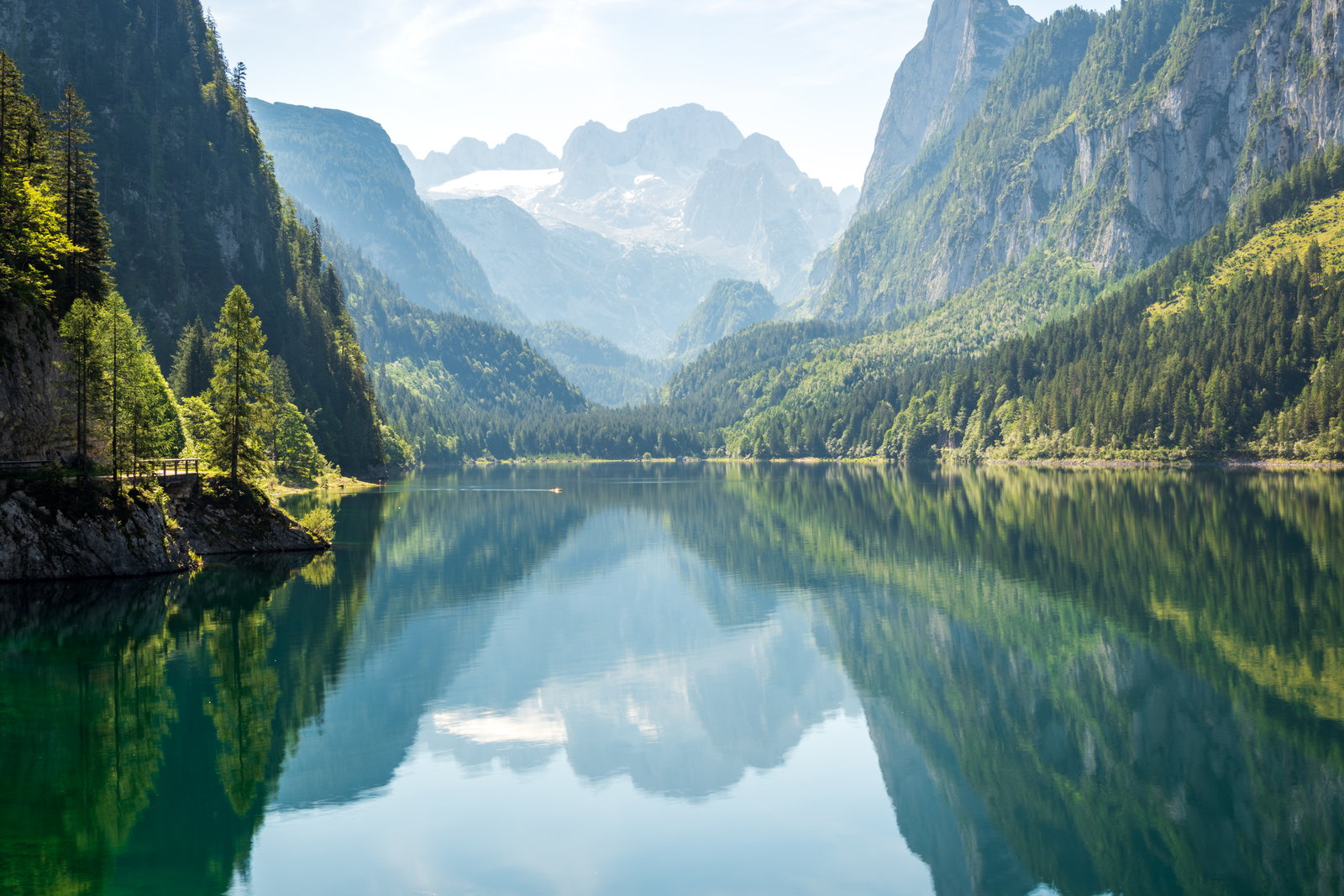
A gravel track past the Gosaulacke to the last lake in the valley, an hour and a half in — greener, emptier and directly under the Dachstein glacier.
About The trail to the Hinterer Gosausee
Get directionsBeyond the Vorderer Gosausee the valley keeps going, and a wide gravel track follows it. The Gosaulacke, a shallow bay-green lake with dead trees standing in it, comes after about an hour; the Hinterer Gosausee, at 1,154 metres and right under the glacier, after roughly an hour and a half. The walking is easy and almost flat, and the traffic thins with every kilometre — most visitors turn round at the first lake.
The Hinterer Gosausee is a different picture from the front one. It is smaller, paler and closer under the ice, with scree and low pine instead of forest around it, and the Dachstein no longer at the end of the valley but directly overhead. On a still day it mirrors just as cleanly, and there is nobody in the frame.
The track is in shade for much of the morning and gets its light in the middle of the day, which is the reverse of the front lake — so the two work as a sequence rather than a choice: reflection first, then walk in.
Snow closes the upper valley from about November and lies late into spring; in winter the track is a ski and snowshoe route, not a walk. A horse-drawn shuttle runs part of the way in summer. Check the season and the conditions before committing to the full distance.
Best time to shoot
Middle of the day in summer, when the upper valley finally gets its light; walk in early to have it empty
Tips
Allow three hours there and back to the Hinterer Gosausee and take water — there is no service beyond the first lake. In winter this is a ski and snowshoe route rather than a walk, so check conditions before setting out.
Recent work in Gosau & the Gosausee
Portfolio shots by photographers covering this area

Dani H.
View profile →
Dani H.
View profile →
Dani H.
View profile →
Angela K.
View profile →
Dani H.
View profile →
Dani H.
View profile →
Dani H.
View profile →
Dani H.
View profile →
Dani H.
View profile →
Dani H.
View profile →
Dani H.
View profile →

Dani H.
View profile →

Jessica L.
View profile →
Dani H.
View profile →
Dani H.
View profile →
Dani H.
View profile →
Dani H.
View profile →
Dani H.
View profile →
Dani H.
View profile →
Dani H.
View profile →
Dani H.
View profile →
Dani H.
View profile →
Angela K.
View profile →
Dani H.
View profile →
Dani H.
View profile →
Dani H.
View profile →
Dani H.
View profile →
Dani H.
View profile →
Dani H.
View profile →
Dani H.
View profile →
Dani H.
View profile →
Dani H.
View profile →
Photographers who shoot at The trail to the Hinterer Gosausee
Hand-picked professionals working in Gosau & the Gosausee

Real reviews from Gosau & the Gosausee photoshoots
Mariella G.
We were incredibly lucky to have Jewgenia as our wedding photographer in September, and we couldn't be happier! From our very first meeting, we knew she was the perfect fit for us and our celebration. Communication was so pleasant and…

Jewgenia B.
Photographer
Tanja K.
The lovely Jewgenia photographed our civil wedding ceremony, and we are absolutely thrilled with the results and the entire collaboration. We clicked with her right from our initial meeting and knew immediately that she was the perfect…
Jewgenia B.
Photographer
Marlene
For our wedding, nothing mattered more to us than capturing the special moments and emotions forever. So naturally we had pretty high expectations of our photographers and videographers – and finding them was probably one of the biggest…

Ian P.
Photographer
Other spots in Gosau & the Gosausee
The Vorderer Gosausee and the Dachstein reflection
A green lake at 933 metres that holds the Dachstein, its glacier and the Gosaukamm towers upside down on a calm morning — and it is thirty seconds from the car park.
The Gosaukamm ridge
A wall of limestone teeth running for ten kilometres along the western side of the valley, with the Bischofsmütze at the far end — the hardest edge in a soft landscape.
The Zwieselalm meadows and the Gosaukammbahn
A cable car lifts to open alpine pasture at about 1,475 metres on the far side of the valley, and from up there the whole Gosaukamm stands in profile.
Ready to book?
Our concierge team will hand-pick 2-3 photographers who know The trail to the Hinterer Gosausee — free of charge.